BILBILIS AUGUSTA: URBANIZATION
![]()
|
|
BILBILIS AUGUSTA: URBANIZATION |
|
|
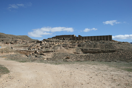
The plan of the city of Bilbilis was imposed in an important part by the orography of the terrain; setting on the hillsides, the buildings had to be adapted to these hillsides. In order to gain plain terrain where they could site the big public buildings, and even the private houses, they had recourse to the terraces, so that the city had a terraced aspect in different levels. The terraces inside a city was a phenomenon well known in Asia Minor (Priene, Pergamon or Miletos were good examples) and in the western Empire (Tarraco or Saguntum were organized in the same way). So, the archaeologists have found in Bilbilis remains of ramparts and streets with outside staircases near the thermae. |
|
View of the archaeological site of Bilbilis (Photo: Roberto Lérida Lafarga 16/03/2008) |
|
|
|
|
|
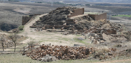
Approximately in a space near the forum and the theatre the two main streets crossed, like the cardo and the decumanus; these streets came from two gates to access to Bilbilis in the walls; one of these gates was located in the low town, near the fertile plain of the Jalon –in the Barranco de los Sillares-; at both sides of this street there were rich houses and a temple in Ionic order, whose foundations are preserved.
Plain area between the hills where the two main streets of Bilbilis crossed ; this view was taken from the thermae, where started one of these main streets up to the forum. (Photo: Roberto Lérida Lafarga 16/03/2008) |
|
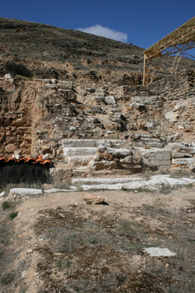
Street in rampart and with outdoor staircase to save the high ground in the hill and the terraces. (Photo: Roberto Lérida Lafarga 16/03/2008) |
|
|
|
|
|
The streets had neither a fixed width nor a regular plan; they were adapted to the ramparts and the terraces. There were paved streets with big irregular flagstones in limestone, concretely, the cardo maximus, or main street that connected the thermae and the forum; this street climb steeply to reach the forum. The main streets in Bilbilis are now interred in order to be preserved because large trucks were driven in the archaeological site and it is necessary preserved them from the trucks. |
|
|
|
|
|
|
|
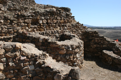
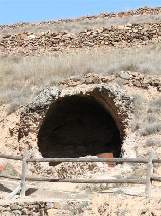
The hill was also a problem to the engineers in an essential aspect for the Roman cities: the supply of water. The Jalon River stays at the foot of the hill and it was very complicated to try to lift up water from the river up to the city to supply it completely. So, it was created an important network of cisterns and canalizations to its system of supply and distribution of water in the city; in fact, the cisterns seems to have been located in a strategical and organized way, because they are approximately at the same distance and their sittings were selected. In this sense we must say that up till now Bilbilis, with its more than 60 discovered cisterns –probably there were more-, is the city of the Roman Empire that had more cisterns according to its size and proportion; we must consider this fact as normal, because the city is on a hill and the river flows on the foot of the hill, so that it could not be supplied from the river, while the orography in the zone made non-viable the construction of an aqueduct to supply water to the city. So, the cisterns to store rain water or water from torrents were the best method of storing and supplying the esteemed liquid. However, it was necessary too to establish a network of pipes to connect the cisterns with the thermae, the nymphaea, the public buildings, etc. |
|
One of the cisterns of Bilbilis; this is in the domus of the nymphaeum, close to the fountain. (Photo: Roberto Lérida Lafarga 16/03/2008) |
|
|
|
|
|
These cisterns could be simple rooms, rectangular or square with only one nave and its corresponding vault, or they could have inner divisions to decant and purify the water. The walls of most of the cisterns were made of opus caementicum –concrete-, outer covered with block of stones and we must suppose that their inner side were covered with opus signinum -impermeable hydraulic concrete-. |
|
Other cistern in Bilbilis; this is close to the thermae and undoubtedly it supplied water to the thermal complex. (Photo: Roberto Lérida Lafarga 16/03/2008) |
|
|
|
|
|
|
|
Sources: - MARTÍN BUENO, Manuel y SÁENZ PRECIADO, Juan Carlos: Bilbilis, Calatayud, Zaragoza, 2005 - MARTÍN BUENO, Manuel y MAGALLÓN BOTAYA, M.ª Ángeles: Cuaderno de campo Grupo URBS: Bilbilis y Labitolosa, Zaragoza, 2006 |